
 CQ Maps has been an advertiser here for a couple of months now. Shortly after they started advertising here, they sent me one of their flagship products—a custom azimuthal projection, or great circle, map. I’m a little tardy with my review, but better late than never is what my mother used to say.
On an azimuthal projection map, according to Wikipedia, “all points on the map are at proportionally correct distances from the center point, and that all points on the map are at the correct azimuth (direction) from the center point.” In other words, an azimuthal projection map is designed to quickly tell you the bearing of the shortest path between your location and another location.
This is exactly what you want if you have a directional antenna. You normally want to point your antenna directly at the target.
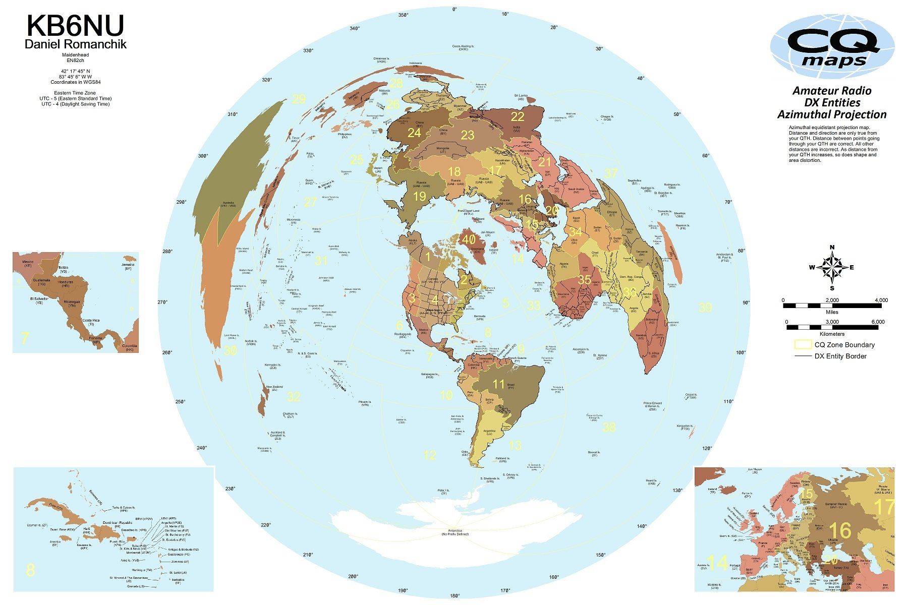
You only get a true bearing from a map like this when your location is at the center of the map. So, what CQ Maps does is to create a custom map for you based on your location. An image of my map is shown above. As you can see, the map is centered on Ann Arbor, MI. Other customizations include call sign, full name, Maidenhead locator, latitude and longitude, and time zone with UTC offset.
Finding a bearing is very easy. I place a yardstick between my location and the DX location then easily read the bearing at the edge of the map. For example, the bearing for the shortest distance between SE Michigan and central Europe is about 50°, even though Michigan and Central Europe are about at the same latitude. If I’d use a conventional map to point my antenna, I’d be about 40° off!
The map measures 24-in. high by 36-in. wide and includes all listed DX entities, CQ zones and recent political borders. The maps cost $30 if printed on presentation matte paper, $35 if laminated, or $40 if printed on Tyvek.
The only quibble I have is that all of the countries are different shades of brown. I would have preferred the map to be a little more colorful, but that’s a minor complaint.
Thanks, CQ Maps! This is a nice addition to my shack. Now, all I need is a beam so that I can really take advantage of the map.
Nice map. I’ve always put up with one centered on the US, which is of course, a bit off for those of us in SE Michigan.
I always thought it would be neat to put a servo in the middle of one with a pointer tied to my rotor, to give a real-time indication of direction.
I suppose the end-game of something like that would be to have a large-screen TV mounted on the wall, with a custom map, and displaying the rotor direction. You could zoom into the North America continent, which I’ve wanted to, to make it easier to point to states on the West Coast or South West. Ham Radio Deluxe has a rotor control/display which I use from my laptop, but I’ve not played with seeing if it has other projections aside from the default Mercator.
Hi, How can I order a zimuthal circle map with my city in the center point? Does it include prefexis? Can you send me a picture of one to see how it looks?
My city is Temuco, 700km south of Santiago, Chile
Thanks-
Gerardo
CE6PCM
I bet that CQ Maps could make one for you. All you would have to do is to send them your coordinates.
Ich hatte gerne eine benutzerdefiniert Karte.
Welche Daten von mir werden gebraucht?
vy73 de Volker DK9BO